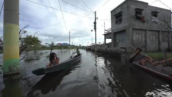
Several areas of the Philippines, notably Metro Manila, are sinking as sea levels rise because of climate change.
This, according to a study done by the University of the Philippines’ (UP) Resilience Institute, which discussed the cause of Manila’s sinking and its effects in terms of flooding and land subsidence.
Dr. Alfredo Mahar Lagmay said most affected land subsidence is the northeastern part of Manila Bay, namely the CAMANAVA (Caloocan, Malabon, Navotas and Valenzuela) area, which have high to moderate hazard of flooding due to sea level rise and ground sinking during rainy season.
Some of the surrounding communities of Manila Bay were already submerged in water for several years.
Among the worst communities affected by this phenomenon is Barangay Pariahan in Bulacan where the whole area is submerged in water which started in the early 2000s, the study as posted on the website showed.
“As we experience climate change in the Philippines, intense rainfall is more likely to recur, leading to worse flooding in these coastal communities and other nearby areas of Metro Manila.” Dr. Lagmay said, emphasizing that flood projection of Manila after 100 years where there will be more areas that will be affected.
The average rate of the subsidence in CAMANAVA and Manila based on their studies is 2 cm/yr from 2003 to 2011.
The study also showed that the subsidence was driven by excessive groundwater extraction in the form of ground wells and fishponds.
The researchers also discussed the effect of the Pinatubo eruption in the area, wherein the landscape drastically changed, including the flow of the streams and rivers.
In terms of industrialization, Lagmay explained the increase in population growth in Metro Manila, where a greater need of water has driven over-extraction of fresh water from the ground.
This adds to the rate of land subsidence in Metro Manila and other nearby coastal communities. The growing population, urbanization, and poor urban planning constitutes the perfect recipe for a disaster when natural hazards strike.
Years of data
Led by Lagmay, the team analyzed ground movement from 2014 to 2020 using an interferometric synthetic aperture radar, or InSAR, which found that some areas sink by as much as 109 millimeters per year.
In the Greater Manila Area, subsidence rates are highest in industrial zones, particularly in Bulacan, Cavite, and Laguna.
These areas, characterized by large factories and economic zones, require substantial water for their operations, leading to excessive groundwater extraction. As a result, the ground is slowly collapsing under the weight of urban development.
Residential areas are not immune to this phenomenon.
Suburbs in Bulacan and Cavite, which have seen rapid population growth in recent years, are also sinking. The situation is worsened by the Marikina Valley Fault's proximity, which introduces additional risks of structural damage due to fault-related ground movement.
In these areas, residents have reported cracks in homes and infrastructure, a clear sign of the ongoing subsidence.
Outside urban centers, agricultural lands are also experiencing significant subsidence.
In provinces like Bulacan, where rice fields and fishponds are prevalent, groundwater extraction for irrigation is causing the land to sink.
This not only threatens agricultural productivity but also increases the risk of flooding, particularly in coastal areas where sea levels are rising due to climate change.
In coastal towns like Obando, Bulacan, the impact of subsidence is already visible. Roads are submerged during high tides, and some homes are permanently flooded. Due to this, residents have resorted to elevating their houses or abandoning the ground floor altogether.
Flooding
The worsening floods in these areas are not primarily due to increased rainfall but are instead a direct consequence of land subsidence, as the ground sinks faster than the sea level rises.
Currently, the National Water Resources Board (NWRB) regulates water extraction through permits, but the monitoring system is insufficient. With only 34 monitoring wells across the country, the scale of the problem far exceeds the current capacity for oversight. InSAR technology offers a promising solution for long-term monitoring of ground subsidence.
By analyzing a series of interferograms over time, authorities can identify areas at risk and take preventive measures.
However, this requires investment in technology and infrastructure, as well as stricter enforcement of groundwater extraction regulations.
Without intervention, the subsidence will continue to worsen, posing a significant threat to the environment, infrastructure, and the livelihoods of millions of Filipinos.
The sinking cities of the Philippines are a stark reminder of the need for sustainable development practices and the urgent need to address environmental issues before they reach a tipping point – and destroy the very ground beneath our feet.
Photo Courtesy: UP Resilience Institute
#WeTakeAStand #OpinYon #OpinYonNews #Floods

