


TROPICAL CYCLONE BULLETIN NO. 13 Tropical Storm “#DantePH” (CHOI-WAN) Issued at 5:00 PM, 1 June 2021 Valid for broadcast until the next bulletin at 8:00 PM today
Location of Center (4:00 PM)
The center of Tropical Storm “#DantePH” (CHOI-WAN) was estimated based on all available data at 85 km East Northeast of Guiuan, Eastern Samar or 110 km East Southeast of Borongan City, Eastern Samar (11.4°N, 126.4°E)
Intensity
Maximum sustained winds of 65 km/h near the center, gustiness up to 80 km/h, and central pressure of 998 hPa
Present Movement
North Northwestward at 25 km/h
Extent of Tropical Cyclone Winds
Gale-force winds extend outward up to 100 km from the center.
TROPICAL CYCLONE WIND SIGNALS IN EFFECT
TCWS No. 2
(Damaging gale-force winds prevailing or expected within 24 hours)
LUZON
Catanduanes, Camarines Sur, southern portion of Camarines Norte (San Lorenzo Ruiz, San Vicente, Talisay, Daet, Basud, Mercedes), Masbate including Ticao and Burias Island, Albay and Sorsogon
VISAYAS
Eastern Samar, Samar, Northern Samar, Biliran, and the northeastern portion of Leyte (Carigara, Barugo, San Miguel, Babatngon, Tacloban City, Alangalang, Tunga, Santa Fe, Palo)
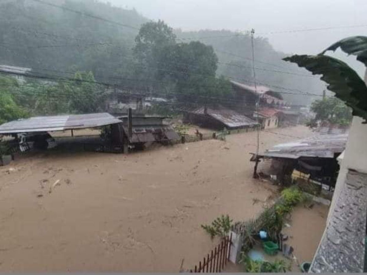
'DANTE' WREAKS HAVOC OVER S. LEYTE. Portions of Maasin. Southern Leyte experienced heavy flooding after tropical storm "Dante" plowed through Eastern Visayas on Tuesday (June 1). At least three people have been reported killed and one missing after "Dante" indunated parts of Eastern Visayas and Mindanao. ( TRISTAN JUN ESCALAMADO)
TCWS No. 1
(Strong winds prevailing or expected within 36 hours)
LUZON
Rizal, Laguna, the southeastern portion of Batangas (Lobo, San Juan, Rosario, Taysan, City of Tanauan, Santo Tomas, Malvar, Lipa City, Padre Garcia, Ibaan, Batangas City, Balete, Mataasnakahoy, San Jose), Quezon including Polillo Islands, the rest of Camarines Norte, Marinduque, and Romblon
VISAYAS
The northeastern portion of Aklan (Lezo, Numancia, Banga, Kalibo, New Washington, Balete, Batan, Altavas, Makato, Tangalan), the northeastern portion of Capiz (Mambusao, Sapi-An, Ivisan, Roxas City, Panitan, Sigma, Panay, Pontevedra, President Roxas, Pilar, Ma-Ayon, Dao, Cuartero), the northeastern portion of Iloilo (Sara, San Dionisio, Batad, Estancia, Balasan, Carles, Lemery, Ajuy, Concepcion), the northeastern portion of Negros Occidental (Manapla, Cadiz City, Sagay City, City of Escalante, Toboso, City of Victorias, Calatrava), the northern portion of Cebu (Balamban, Asturias, Tuburan, Tabuelan, Sogod, San Remigio, City of Bogo, Borbon, Tabogon, Bantayan Islands, Daanbantayan, Medellin, Catmon, Danao City, Carmen, Compostela, Cebu City, Liloan, Consolacion, Mandaue City, Lapu-Lapu City, Cordova), the northeastern potion of Bohol (Getafe, Talibon, Trinidad, Bien Unido, Ubay, San Miguel, Alicia, Buenavista, Mabini, Candijay, Anda, Inabanga, Guindulman, Dagohoy, Pilar, Danao, Pres. Carlos P. Garcia), the rest of Leyte and Southern Leyte
MINDANAO
Surigao del Norte including Siargao and Bucas Grande Islands, Dinagat Island, the northern portion of Agusan del Norte (Kitcharao, Jabonga, Santiago, Tubay, City of Cabadbaran, Magallanes, Remedios T. Romualdez, Butuan City), the northern portion of Agusan del Sur (Sibagat), and the northern portion of Surigao del Sur (San Miguel, Tago, City of Tandag, Cortes, Lanuza, Carmen, Madrid, Cantilan, Carrascal)
TCWS#1 in other areas is hereby lifted.
HAZARDS AFFECTING LAND AREAS
Heavy Rainfall
Today through tomorrow morning, Tropical Storm “DANTE” is forecast to bring:
• Moderate to heavy with at times intense rains over Surigao del Norte, Dinagat Islands, Leyte, Southern Leyte, Biliran, Masbate, and Romblon
• Moderate to heavy rains over Surigao del Sur, Agusan del Norte, Camiguin, Samar, Bohol, the northern portion of Cebu including Bantayan and Camotes Islands, Capiz, Iloilo, Sorsogon, Albay, Camarines Norte, Camarines Sur, Marinduque, and the southern portion of Quezon
• Light to moderate with at times heavy rains are also likely over Misamis Oriental, Agusan del Sur, Bukidnon, Catanduanes, and the rest of Visayas.
• Under these conditions and considering antecedent rainfall, scattered flooding (including flash floods) and rain-induced landslides are highly likely, especially in areas with high or very high susceptibility to these hazards as identified in hazard maps. Adjacent or nearby areas may also experience flooding in the absence of such rainfall occurrence due to surface runoff or swelling of river channels.
Severe Winds
• The tropical storm will bring strong winds to gale-force winds over the areas where Tropical Cyclone Wind Signal #2 is hoisted. Such conditions may bring generally light to moderate damage to structures and vegetation.
• Strong winds (strong breeze to near gale) which may cause generally very light damage to structures and vegetation will be experienced in areas where TCWS #1 is in effect.
HAZARDS AFFECTING COASTAL WATERS
• In the next 24 hours, rough to very rough seas will be experienced over the seaboards of areas where TCWS #2 is in effect, and the eastern seaboard of Caraga (2.5 to 4.5 m). Sea travel is risky for small seacrafts over these waters. Mariners without the proper experience should immediately seek safe harbor.
• Moderate to rough seas (1.2 to 3.0 m) are also expected over the eastern seaboard of Davao Oriental and the remaining seaboards of areas where TCWS #1 is in effect. Mariners of small seacrafts are advised to take precautionary measures when venturing out to sea. Inexperienced mariners should avoid navigating in these conditions.
TRACK AND INTENSITY OUTLOOK
• “DANTE” will continue moving generally northwestward until tomorrow evening. On the forecast track, the center of the tropical storm is forecast to make its initial landfall over Eastern Samar between tonight and tomorrow early morning. This tropical cyclone is more likely to remain as a tropical storm category prior to landfall. “DANTE” may weaken into a tropical depression on Thursday and to Low Pressure Area on Saturday.
Considering these developments, the public and disaster risk reduction and management offices concerned are advised to take all necessary measures to protect life and property. Persons living in areas identified to be highly or very highly susceptible to these hazards are advised to follow evacuation and other instructions from local officials. For heavy rainfall warnings, thunderstorm/rainfall advisories, and other severe weather information specific to your area, please monitor products issued by your local PAGASA Regional Services Division.
Unless an intermediate bulletin is released, the next tropical cyclone bulletin will be issued at 8:00 PM today.
Source: DOST-PAGASA